The HUCK FINN--Adventures of a canal boat on North America's waterways

Photos, captain's notes, and crew's tales from the 26' canal boat HUCK FINN. Itinerary: roundtrip St. Pete. FL/St. Paul MN.

Monday, May 29, 2006

This red "nun buoy" is showing the effects of about 4.5 mph river current. I was moving upstream on the Mississippi delivering a boat in April '06. Though not at flood stage, this is a high water current, near Cape Girardeau, MO.
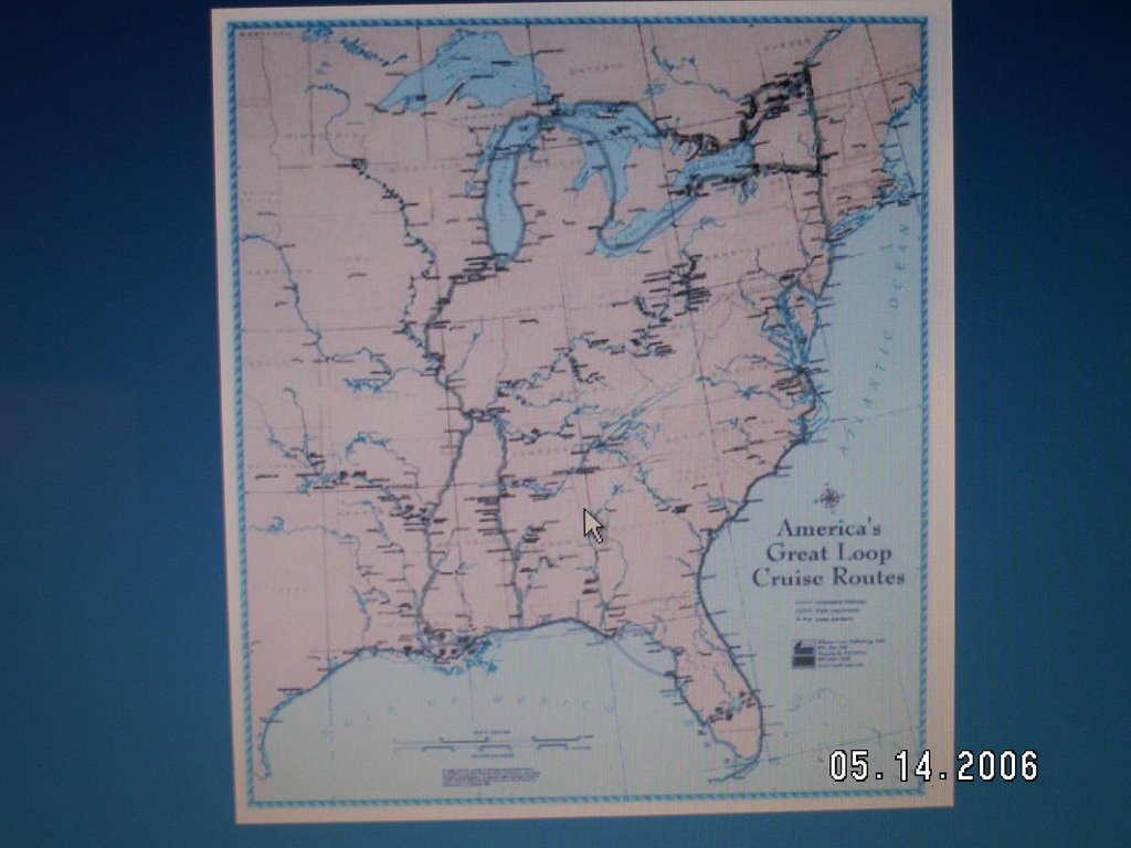
The "Caboose" is no more; she (he) has been renamed...the HUCK FINN will be leaving St. Pete. August 1 headed for St. Paul, MN. First mate JO recently supervised installation of new cushions and curtains. An insecure captain might be apologetic about the flowery yellow material, but, heck, some things just aint worth fightin' about. After all, I got to pick out the 14" diameter 3-blade bronze propeller. Captain Brion will be back on the water for a boat delivery part way from Philadelphia to St. Petersburg. This will be my 2nd trip across Chesapeake Bay, which can be challenging with weather, tidal currents and ocean vessels coming and going. The boat is a 27' Norsea sailboat, a classic bluewater cruiser capable of circumnavigation. I'll bring her about 1/2 way to St. Pete. The owner will finish the delivery. During the trip, I'll publish some more photos and entries to CAPTAIN'S NOTES.

Also, in the next week or so will publish new photos of the upgraded HUCK FINN. Two months before casting off for the North country!

Sunday, May 14, 2006


August 1, '06, the Caboose leaves Saint petersburg, Fl for St. Paul MN. This trip covers most of the western portion of what is known as the "Great Circle Route" or the "Great Loop."

Not easy to identify on this small scale chart, the route begins in Tampa Bay, crosses the Gulf of Mexico to the Florida panhandle/Gulf Coast region, then enters the Gulf Intracoastal Watereay to Mobile, AL. Thence northward by way of the Mobile River, Warrior River and Tennesee-Tombigbee Waterway to Pickwick Lake and the Tennessee River. Next comes a 50 mile stretch of the Ohio River to Cairo,IL, where a hard right turn puts us on the Mississippi River headed upstream to St. Louis and beyond. Twent-nine locks later, the Caboose makes landfall in St. Paul, almost exactly 2,000 miles from St. Pete!

Thursday, May 11, 2006


A portable outhouse and its unwary occupant could be upended by a careless boater's wake...


...if it wasn't secured by a 20,000 lb. test barge line!


Whitten Lock. Photo 3. (see text below)


Whitten Lock photo 2


here I am on the Adagio, waiting for the massive downstream gates to open on the Jamie Whitten Lock. I much prefer the original name--Bay Springs Lock--But ex-Mississippi congressman Whitten had to be paid for his pork. At 84 feet, this lock has the fourth highest lift (or drop) of any in the U.S. It is the northernmost in a series of ten that helped to create the Tennessee-Tombigbee Waterway. This new route, completed in 1985, creates a shortcut from the Tennesse River to the Gulf of Mexico, bypassing the lower Mississippi, and accessing the Gulf at Mobile, AL. As with most massive man-made projects, there were losses: pastures and farmlands were turned into lakes, many native American historic sites were flooded, as were Civil War battlefields. And the 29 mile long "cut", or canal is in many places an unhealed scar on the landscape...not at all blended into its surroundings. But overall, the waterway is secluded and serene, with miles of forested shoreline and naturally eroded rock bluffs.

In the next photo, you are inside the lock, waiting to be raised to the level of Pickwick Lake and the Tennessee River. Millions of gallons of water are released from above the dam to the bottom of the lock, controlled by hydraulic valves. The entire vault is filled in about ten minutes.

Your boat is held securely to the lock wall by a floating bollard, so that no lines need to be adjusted during the process. This is a great convenience, compared to managing lines that hang from the top of the lock walls, and need to be taken in or paid out as the water level changes. Photograph 3 shows the midship section of the Adagio secured to the bollard.

Wednesday, May 10, 2006


This abutment is all that remains of a bridge that gained brief international attention in April of 1979. I took the phot during a boat delivery from Florida to Illinois. The river (Warrior R., part of the Tenn-Tom Waterway) was at flood stage and a commercial tug captain had lost control of his vessel in the strong current. An amateur photographer just happened to be on the scene with a video camera and recorded trhe horrific scene of the tug htting the bridge, capsizing and rolling 360 degrees. Amazingly, the tug righted itself on the downstream side of the bridge. All three crew members survived, and the tug ("Cahaba") , out of Mobile, suffered only minor damage. Thanks to the internet, and the network news, the images were seen by millions, including myself. How many people passing this relic today know its history? Soon after the accident, a new railroad bridge was constructed nearby to replace the outdated and damaged span.

In 1999 the restored tug was renamed the "Capt. Ed Harris" and returned to regular use. On my trip upriver in August, I'll be looking for it and hoping to get a picture.

See spectacular photos of the actual event at: http://koti.mbnet.fi/~soldier/towboat.htm

Sunday, May 07, 2006


Sounding the river--determining its depth--used to be done with poles, or a lead line, or by a captain's best guess. Ripples on the water surface may indicate shallows; conversely, "still waters run deep." The outside of a bend in the river generally runs deeper than the inside. "Mark twain" was the call of a deckhand informing the captain how much line was in the water (therefore the depth) when the weighted end struck bottom. Too often, these approximations failed to give a captain the tools he needed for safe navigation. Accidental groundings were the most common cause of riverboat damage before the rivers were charted and before electronic echo-sounders were invented.

The pictured survey boat is "mapping" the riverbottom with a gang of depth sounders protruding into the water on both sides. The precise location of each depth reading is determined by a continuous GPS signal which is correlated by computer with the sounders.

The resulting 3-D map of the bottom will be used to identify silted areas in or near the shipping channel that need to be dredged. The data will also be used to update charts and to relocate markers. Commercial tug captains rely upon these markers (buoys and posts) to keep their deep draft vessels from going aground. As with all navigation aids, these markers can be erroneous, and should be used in context with other available information in determining the safest course.

Saturday, May 06, 2006


For three weeks in April, while delivering "Adagio" to Peoria, I scanned the riverbanks for interesting or unusual homes. I collected a number of these photo images into a "river bluff homes" folder. Perhaps a bit macabre, Menard is nonetheless a remarkable "home" to more than 3,100 inmates, many on death row. John Wayne Gacy spent his final days there before being lethally injected for multiple murder convictions. Charles Manson has been at home in Menard for some thirty years.

Slogging against a 5mph current, I had more time than I wanted to absorb the haunting image of this state "penitentiary", built by inmate labor in 1878. I felt oddly self-conscious, wondering whether any of the inmates had windowed cells whereby they could see me passing on the river. Would they be jealous, envious, embittered at the sight of my flagrant exercise of freedom? Perhaps the more hardened souls could notice me with indifference. I felt almost embarrassed at the stark contrast of our lives: freedom versus lockdown.

The sobering reminder of these condemned and forgotten souls was very slow to fade. The renewed sense of my own freedom and opportunity lingers yet today. Nothing I can do for those unfortunates. Plenty I can do to make sure I don't end up in the same predicament.

I don't really look forward to going by Menard again in August. Maybe it will be a rainy summer and the Caboose will have to be trucked past that part of the Mississippi due to excessive current. Que sera, sera .

Thursday, May 04, 2006

This 36' Carver was delivered from Saint Petersburg to Peoria, IL in 18 days. She is tied here to Kidde's floating fuel dock, the only place to tie in Cape Girardeau, MO. Charlie Brown (yeah, that's really his name!) pumped my diesel and gave me permission to tie there for the night. The current on the Mississippi here was flowing about 5mph. It was a treat to walk into town and have a real cooked meal...and a wireless signal for my laptop to send e-mails. This photo was shot in the dim light before sunup, just before I untied to continue the slog upstream toward Saint Louis. Just above Saint Louis, at Alton, I was joined by broRoger and sonSeth...a real highlight of the trip. After two weeks non-stop at the helm, I was glad to let them pilot the boat for long stretches. Iplan to see Charlie Brown again in August, after I leave for St. Paul from St. Pete in the "Caboose." More on that later.


See post below!

After the owners of Lady Elaine spent two weeks in the Bahamas, they re-hired me to bring the boat back to S. Pete. to be sold. Leaving my anchorage at sunup from the East side of Biscayne Bay, I was treated to this view of the Miami skyline. For the rest of the day, I traversed dozens of bridges northward along the Intracoastal Waterway to Port S. Lucie, where I headed back West to revisit Lake Okeechobee.


Why I like to deliver boats! Looking East toward Lake Okeechobee soon after exiting Moorehaven Lock. The Lake is just over the trees to the left. On the right are acres of sugar cane fields that dominate this area on the North edge of the everglades. This 36' Gulfstar trawler ("Lady Elaine") was delivered from Saint Petersburg to Miami in 2005. The serene waters of this canal later gave way to 8 foot seas and 25 kts. of wind on the Lake. Knowing the boat was strong, I opted to by pass safe harborage at Clewiston and brave the 27 mile crossing. In a lesser boat, I would have been scared, as the rolling was extreme--two water jugs and a set of charts slid into the lake from the floor of my steering station before I could grab them. Heading into the waves, the muddy brackish lakewater broke over the bow and crashed into the flybridge, 12 feet above the water. I was tired and wet and mighty glad to see the opening of Mayacca Lock, my escape from the turbulence, some 3 hours later.